
As the technology partner for Analyse Bus Open Data (ABOD), the Ito team joined RTIG on the ‘Introduction to ABOD for authorities and operators’ webinar to talk through the features and provide a demo of the functionality.
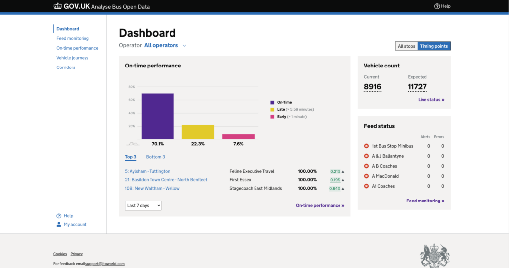
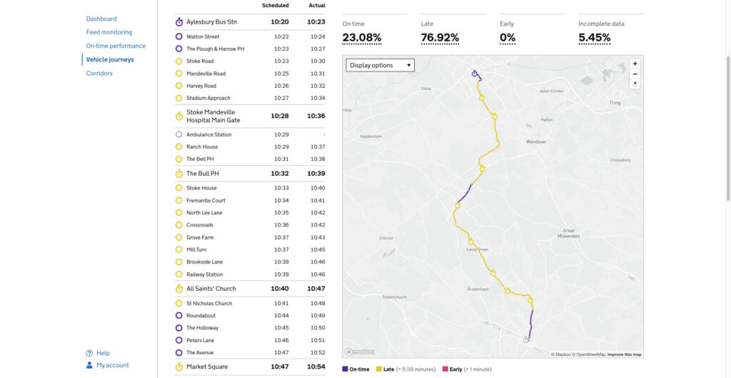
Analyse Bus Open Data (ABOD) is an extension service to the Bus Open Data Service (BODS), that provides free-to-access reporting and analytics to operators and authorities nationally.
The service provides:
- dashboard overview
- feed monitoring
- on-time performance analyses
- vehicle journey analysis
- corridor reporting
ABOD is part of the UK Department for Transport (DfT)’s ongoing investment in bus services, and supports the National Bus Strategy, by helping government, local authorities, and bus operators to:
- perform existing bus data analysis in faster and easier ways
- produce more accurate and detailed performance analysis reports
- improve on collaboration between different organisations
- identify network improvement opportunities
- inform transport policy and compliance monitoring across the industry
RTIG is supporting the UK DfT by promoting the service to ensure operators and authorities know about the service and how they can use it.
Watch the replay to find out more.
Cambridge residents, workers and visitors can now install Citymapper on their smart devices to help them navigate the city and find the quickest route to where they want to go.
The Greater Cambridge Partnership (GCP) recently announced their collaboration with Citymapper – the ultimate journey planning app – as part of the GCP’s goal to make people’s journeys better by integrating up-to-date local bus data into the Citymapper app.
Citymapper is the leading journey planning app and now includes real-time bus data for Cambridge, thanks to GCP’s partnership with Ito that supports efficient and sustainable transport solutions.
The aim of this partnership is to use data integration to improve the information which commuters and visitors can access to help plan their journeys more effectively. This collaboration will aid this process as will other real time data projects being developed by the GCP with the goal of creating seamless, integrated, and accurate travel information no matter the device you use.
Cllr Elisa Meschini, Chair of the Greater Cambridge Partnership’s Executive Board, said: “Being able to travel around a city – knowing the quickest way from A to B – is at the heart of a thriving community. Our collaboration with Citymapper and Ito is about making sure residents, visitors and commuters have the most up-to-date information on their mobile phones to help them get around.”

Cllr Elisa Meschini
Chair of the Greater Cambridge Partnership’s Executive Board
Citymapper, which is available for free download for iOS and Android, uses real-time and local timetable information to suggest the best routes and accurately predict travel times in hundreds of communities worldwide. Cambridge journey planning is now available within the London option in the Citymapper app. The app incorporates a mix of buses, trains, walking, biking, and scooter options – offering users a mix of choices. Personalised routing features help travellers navigate any situation and find the fastest available route.
Liv Walker, VP of Operations at Via, who acquired Citymapper in April 2023, said: “We are proud to work with the Greater Cambridge Partnership to make transportation in Cambridge more efficient and accessible through Citymapper’s journey planning platform. Citymapper’s powerful technology now incorporates localised, real-time public transit data to enable an exceptionally accurate journey planning experience in Cambridge, which creates new opportunities for residents and visitors to connect and explore the city with confidence and ease.”
Along with real-time travel updates, the app also offers estimated time of arrivals (ETAs), giving users the ability to make informed decisions about their journeys. The app’s hands-free voice navigation works across multiple modes of transport, including walking, cycling and scooters. It provides real-time audio instructions that match the chosen mode of transport.
“Ito is proud to play a pivotal role in enhancing the commuter experience through our partnership with the Greater Cambridge Partnership and Citymapper,” stated Amy Bridge, Chief Customer Delivery Officer at Ito

Amy Bridge
Chief Customer Delivery Officer at Ito
This collaboration resonates with various stakeholders, including corporate partners in Greater Cambridge. Dr Andy Williams, business representative on the Greater Cambridge Partnership Executive Board, commented “Businesses, whether big or small, rely on efficient transportation for their employees, suppliers and customers, which is why the integration of real-time bus data through the Citymapper app is so important.”

Dr Andy Williams
Greater Cambridge Partnership Executive Board
The GCP continues to champion innovation and collaboration in transportation solutions, envisioning a future where commuting is streamlined, convenient, and sustainable.
The organisation’s Innovation Prospectus invites forward-thinking companies who’d like to use Cambridge as a dynamic testbed to get in touch. You can work with the GCP on new pioneering projects to help shape the way we travel and improve daily journeys across Greater Cambridge. This could include better ways to manage the transport network, encouraging behaviour change or new modes of transport.
Innovators and tech firms with ideas that can make moving around Cambridge easier are being asked to get in touch with the GCP Smart team via email at [email protected].
In our latest data visualization, we delved into the intricate ways that Zartico’s data enriches the understanding of expenditure patterns and mobility trends among both residents and visitors in the vibrant locale of Salt Lake City.
The NBA All-Star Weekend is one of the biggest events in basketball, drawing crowds from all over the country. Salt Lake City, a city that has long been recognized as a hub of innovation, technology, and creativity hosted the event in 2023.
Harnessing the synergies of Zartico’s geolocation and spending datasets, we have crafted a powerful visual narrative that unveils the patterns of travel and expenditure during the All-Star Weekend.
Ito has been working with the Department for Transport and KPMG on the Bus Open Data Service (BODS) since 2018. Following the successful launch of BODS in 2019, the service continues to evolve – most recently with the addition of an extension Analyse Bus Open Data (ABOD) service launched in 2020.
A world-leading transit data service
The Bus Open Data Service (BODS) is an international first – national bus timetables, fares, and live vehicle locations are all being provided from one open-access, open-source platform. The Department for Transport set the wheels in motion in 2017 with the introduction of legislation requiring these data be published by operators to the service, in order to improve services and passenger satisfaction. Earlier this year they also released a National Bus Strategy, further underlining their ambitions.
Standardised, accurate, timely data to power passenger-centric apps
Consumers know exactly what to expect with BODS. All BODS data conforms to specified standards to ensure consistency. Built-in validation within the BODS service prevents non-compliant data from being published, and Ito managed services perform sophisticated quality checks, notifying operators of suspected inaccuracies. Source data from operators is also converted to developer-friendly GTFS format, and harmonised for the whole of Great Britain. All data is available by bulk download and via an API.
Key numbers:
250+ operators’ timetable and fares data
18,000+ buses’ live location data, updated every 5-30 seconds
Data that is greater than the sum of its parts
We are using BODS data plus Ito World tech to deliver the extension Analyse Bus Open Data service. This powerful tool generates rich reporting and analyses – the insights from which are helping the Department for Transport to enforce legislation, and shape future policy. Operators and authorities can also pinpoint network improvement opportunities, and measure and track efforts towards the National Bus Strategy goals such as punctuality, accessibility and emissions.
Find out more
The Ito World technology and products used in BODS are versatile, mode-agnostic, and virtually unlimited in scope and scale.
Contact us to find out more about our work, and how we can help you meet your transit data aspirations.